At the confluence of two major rivers, the Fortymile and the Yukon, is the historic settlement of Forty Mile. The Fortymile River got its name, not because of its length, but because of its estimated distance downriver from the old trading post of Fort Reliance. The Fortymile begins in Alaska and, with its great network of tributaries, drains an area of 1830 km2 (706 square miles).
For over 2000 years, First Nations people have come here to hunt, fish, trade and visit.
It is an important place for our ancestors and the Yukon’s first real non-native settlement. Forty Mile became a mining centre ten years before the Klondike Gold Rush and the building of Dawson City. This was one of the first major contact points between First Nations people and the newcomers to the upper Yukon River valley. The historic site also has two other parts that are located across the river: Fort Cudahy a trading post established in 1893 and Fort Constantine, the Yukon’s first North-West Mounted Police post, built in 1895.
Today, the Forty Mile, Fort Constantine and Fort Cudahy Historic Site is co-owned and co-managed by the Tr’ondëk Hwëch’in and the Yukon Government. Forty Mile is a Historic Site under the THFA, and the site will be designated as a Yukon Historic Site under the Historic Resources Act.

Fortymile Caribou Herd
During the early 1900s, the herd was the largest in Alaska and one of the largest in the world. In 1920, renowned biologist Olaus Murie estimated that the herd was as large as 568,000 animals. At that time, the herd ranged from Whitehorse, Yukon, to the White Mountains, north of Fairbanks, Alaska – some 85,000 square miles.
Due to periodic cold winters, over-hunting, and high predation rates, the herd dwindled to so few animals that, after 1974, the herd was rarely sighted in Yukon. In 1994 the Fortymile Caribou Herd Management Planning Team was organized, representing public and government agencies in both Alaska and Yukon. Through a program of controlled hunting, non-lethal predator control and habitat protection, the herd recovered to an estimated 40,000 animals in 2002. You can learn more about the herd here.
Traditional Hunting Methods
Elder Mary McLeod explained how that people from Forty Mile and Dawson areas hunted together in the fall. They met at a long caribou fence in the mountains near Chicken, Alaska, southwest of Forty Mile. Caribou were driven into this structure where they would be trapped by snares set into the fence then shot with bows and arrows or stabbed with spears. Other times, the caribou were driven into a ring of people, where the disoriented animals were easy prey for arrows.
After the hunt, women cut up the meat on site. Following a feast of fresh meat to celebrate the successful hunt, the rest of the catch was either dried or, in late fall, frozen. Extra meat could be cached on scaffolds out of reach of animals. Frozen sections of meat were also stored right on the ground, covered with hides, then secured with rocks until the meat was needed.
Once the Tr’ondëk Hwëch’in began using rifles, the hunt changed. Hunting became more of an individual rather than a group activity. From the early 1900s, market hunting was an important income source. Every year, tonnes of meat were sold to Dawson butchers. Chief Isaac protested many times about how non-native hunters were over-hunting the herd making it harder for First Nations people to earn a living.
Grayling
At Fortymile, there were good fat grayling. They’re hard, not soft like some other places. I don’t like soft fish.
MARY MCLEOD, 1974
The Arctic grayling (Thymallus arcticus) is called srejil in the Hän language. This fish is fairly common in Yukon streams and lakes. While it has been known to grow up to almost 4 kg, the average weight is under 1 kg. The flesh of the grayling is light and mild in flavour. As the grayling spawn in the spring, they would be present in significant numbers at the mouth of the Forty Mile River just at the end of winter. The Hän from the Forty Mile and Dawson area gathered here in spring to catch fresh fish, usually through the ice using a line and hooks.
We used to go up from Eagle to Forty Mile area. At the mouth, we used to go grayling fishing too – in the springtime. Bunch of dog teams go up there…just use a rod – fish at the mouth. Chop a hole right through the ice.
Silas Stevens, 2005
Grayling Fishing at Forty Mile in 1938
Claude Tidd was an RCMP officer, outdoorsman and talented photographer. Tidd and his wife Mary lived and worked in many Yukon communities. After leaving the force in 1935, he worked as a fur trader in Forty Mile and Old Crow. Hear his story:
During the spring months the supply of moose and caribou meat often runs short and the native Indians of the Yukon must rely a great deal on fresh fish for food. Many of those living near Dawson City make a round trip of a hundred miles to the favorite fishing-grounds by dog-team. Little preparation is needed for the trip: a blanket, a tea-kettle with a little tea and sugar, a little flour are thrown into their toboggan and they are off. After the long cold winter months, travelling is pleasant during the sunny days of April.
On arrival at the selected spot, no time is wasted in deciding on the proper type of fly to be used – none is necessary. A thin willow is cut from the bank; almost any kind of twine will do for a line, and the hook, which is usually the only piece of equipment that has to be bought, is baited with a little piece of bacon, or if none of this is available, then a piece of old cotton cloth is wound round the hook and the fun is ready to begin; though perhaps cutting through four feet of ice with a good ice chisel can hardly be called fun.
But once the hole is cut through to the surface of the water and the loose ice shovelled out, the rest is easy. The fisherman shown lying down in the photograph was observed to actually pull out ten fish as quick as he could haul them out and drop the baited hook back into the water. There are, of course, long periods when there are no bites; but usually an Indian has plenty of patience – and lots of time.
Mary McLeod (c.1893 – 1987)
Mary McLeod, a Hän speaker who grew up in Eagle, is remembered as a hard worker, a woman skilled in living on the land, a teacher of traditional ways and a gifted storyteller. At age 18, she married Simon McLeod, a Hän man from Moosehide. Their first home together was near Forty Mile. During their years at Forty Mile, the McLeods made much of their living from fishing. Mrs. McLeod told of how her husband spent $200 to buy a fish wheel from “Old Man Fox” in Dawson City. They also netted salmon, using nets that Mrs. McLeod made herself, and sold most of their catch in Eagle, Alaska. The McLeods raised four children and one adopted child.
Mary McLeod was an independent and self-sufficient woman. She loved to hunt and trap, and even enjoyed chopping firewood. When she travelled in the bush, she took only a rifle and light camping gear, expecting to forage for her own meals. After the McLeods moved to Moosehide, Gramma McLeod taught many children through her stories and by sharing practical skills of how to live on the land. Mary McLeod Road, which goes up the Dawson Dome, was named after this respected elder in the late 1990s. Learn more here.
Anderson Family
They fish [salmon] and made lots of dried fish for dog teams and, I guess he sold it. A lot of it – sold to the police, RCMP, whatever they call it – Northwest Mounted Police ... I know they had horses, and they had a big farm too. They sold vegetables eh, grandpa. Fish, dried fish and sold it. Kind of a farmer-fisherman, I guess.
2005, MARGARET TITUS: TALKING ABOUT THE LIFE OF PETE ANDERSON AND HIS FAMILY
Pete Anderson, a Swede, travelled to the Klondike in 1898 with his partner Percy DeWolfe. The pair was too late to stake claims but found a more reliable income from fishing, market hunting and hauling freight to the mines. The men became good friends with Charlie Adams and his family at Twelve Mile. Here they met, and eventually married, his two foster daughters, sisters named Mary and Jessie Phillips.
Pete and his wife Mary raised their family at Forty Mile. The Andersons were all hard workers and did a bit of everything. For a time, they ran a wood camp, cutting cordwood to fuel the hungry boilers of the sternwheelers. Pete ran the community store. They also farmed in summer and trapped in winter. During the salmon runs, the Andersons had a large fishing operation and sold tons of dried salmon to the RCMP for their dog teams. Their son, Arthur Anderson, made the original asbestos discovery at Clinton Creek, eventually resulting in a major mine and settlement.
Percy DeWolfe
Percy DeWolfe is best known for his exploits on the winter mail run between Dawson City, Yukon and Eagle, Alaska. By horse, dog team and boat, Percy delivered mail to the remote Alaska community year-round for nearly 40 years. He earned the nickname “Iron Man of the North” for his perseverance in the most severe weather and no matter the road or river conditions. On one harrowing occasion, while his horses and wagon were breaking through the river ice, Percy risked his life to throw 20 bags of mail to the shore. In 1935, Percy received a silver medal from King George in recognition of his achievements.
Percy and his family lived at Halfway, about 20 miles downriver from Dawson City. Percy and his sons, William, and Walter operated a fish camp here every summer.
To celebrate Percy DeWolfe and his achievements, every year mushers and their dog teams head to Dawson City to run “The Percy”. The Percy DeWolfe Memorial Race follows the Yukon River ice from Dawson City to Eagle, Alaska and back.
To learn more about this race, visit thepercy.com.
Forty Mile Firsts
- the Yukon’s first major gold strike (September 1886)
- the development of new placer mining techniques
- the Yukon’s first real non-native settlement (1887)
- the Yukon’s first residential school (1893)
- first meeting between Canadian government representatives and Hän people (1894)
- the Yukon’s first post office (1894)
- founding of the fraternal organization, the Yukon Order of Pioneers (YOOP) in 1894
- Forty Mile became the place where the Canadian Government first raised the flag in the Yukon and collected customs taxes (1894)
- the Yukon’s first Mounted Police post (1895)
Traders
Long before white traders visited the Upper Yukon River basin in the mid 19th century, the Hän were part of an extensive trade network with their neighbours to the north, south and west. They traded birchbark, red ochre, hides and salmon for native copper, obsidian and dentalium shells. When the first non-native traders visited Hän territory, they met people who had never seen a white person but were familiar with kettles, beads, tea, and tobacco.
Jack McQuesten of the Alaska Commercial Company set up a post at Fort Reliance in 1874. The Hän adjusted their way of life, trapping additional fur for trade and spending part of each year near the post.
Prospectors began moving into the Yukon River basin seeking gold. McQuesten and his partners, Al Mayo and Arthur Harper, began stocking mining supplies and their posts made it possible for the miners to overwinter in the north. Soon after the rush to the new diggings, a bustling community of miners, merchants, and entrepreneurs grew up at the mouth of the river. First Nations people, attracted by the goods and services of the new settlement, helped build the new trading post and supplied meat to the miners. Women sold hide and fur clothing to the newcomers and in some cases married prospectors.
Three influential frontiersmen and prospectors encouraged early non-native development and settlement of the upper Yukon River basin including the site that eventually became the Forty Mile community. Jack McQuesten, Al Mayo and Arthur Harper owed much to their First Nations wives, Koyukon women from the lower Yukon River.
To learn more about the early traders of Forty Mile, check out the story.
Gold on the Fortymile
In September 1886, Howard Franklin and Henry Madison travelled up the Fortymile River prospecting along the way. Twenty-three miles up the river, they made the first discovery of coarse gold in the Yukon-Alaska interior. Up to this time, most miners were finding the finer flour gold and this major new development sparked a rush to the new diggings.
Trader Arthur Harper knew that more goods were needed to supply the rush of gold miners and needed to get word outside to his trading partner Jack McQuesten. Tom Williams and a First Nations companion named Bob volunteered to deliver mail by dog team to Skagway in mid-winter. It was a gruelling trip. Tom became deathly ill with pneumonia and Bob carried him on his back through icy winds and deep snowdrifts. A group of Chilkat helped the pair to the Healy and Wilson post. Tom gasped out his message then died.
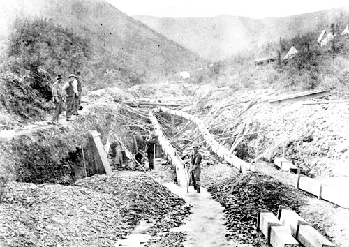
At Forty Mile, gold miners pioneered new mining methods that allowed them to work their claims in winter. They built fires to thaw the frozen ground in layers. These gold-bearing gravels were piled in large dumps, ready to be sluiced or washed down in spring when the streams began running.
Anglican Church
About 200 Miners have passed the present winter in this immediate vicinity, in British Territory. The Indians have learned from them to make whiskey for themselves, and there has been drunkenness of Whites and Indians together with much danger of the use of firearms.
BISHOP BOMPAS, FORTY MILE, TO CHIEF COMMISSIONER OF INDIAN AFFAIRS, OTTAWA, 1893
Buxton Mission, named for a British benefactor, was started in 1887 by Anglican missionary J.W. Ellington on Mission Island just upstream of Forty Mile. Ellington left the country due to poor health and the mission was abandoned for two years. Bishop William Carpenter Bompas first visited Forty Mile in 1891 then returned the following year with his wife, Charlotte Selina Bompas, to set up his headquarters on Mission Island. Together they began the Yukon’s first mission school.
Over the next decade, Bompas was a strong voice on behalf of First Nations people. He wrote many letters to government officials protesting the social ills that came with the introduction of alcohol. He later worked to protect First Nations interests when their land was taken over for mining and settlements, and their prime fishing spots were usurped by the newcomers.
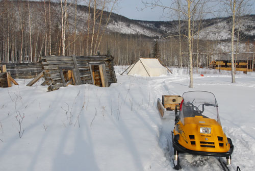
Forty Mile Today
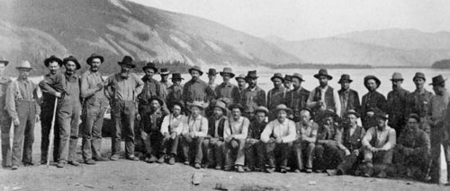
When you look at pictures of Forty Mile today, it is hard to imagine that this was once a town of 600 people and scores of buildings. Hidden in the overgrowth are traces of the log cabin town. As well as eight intact buildings, there are remains of other structures in various stages of decay. Under the bush and deep grass are hollows and berms that mark the outlines of long-gone cabins.
Over the years, many people, groups and governments worked to save the site and document its history. An important issue was who would be responsible for managing the site. In 1998, Tr’ondëk Hwëch’in Final Agreement specified that the Forty Mile, Fort Cudahy, and Fort Constantine Historic Site would be co-owned and co-managed by the First Nation and the Government of Yukon.
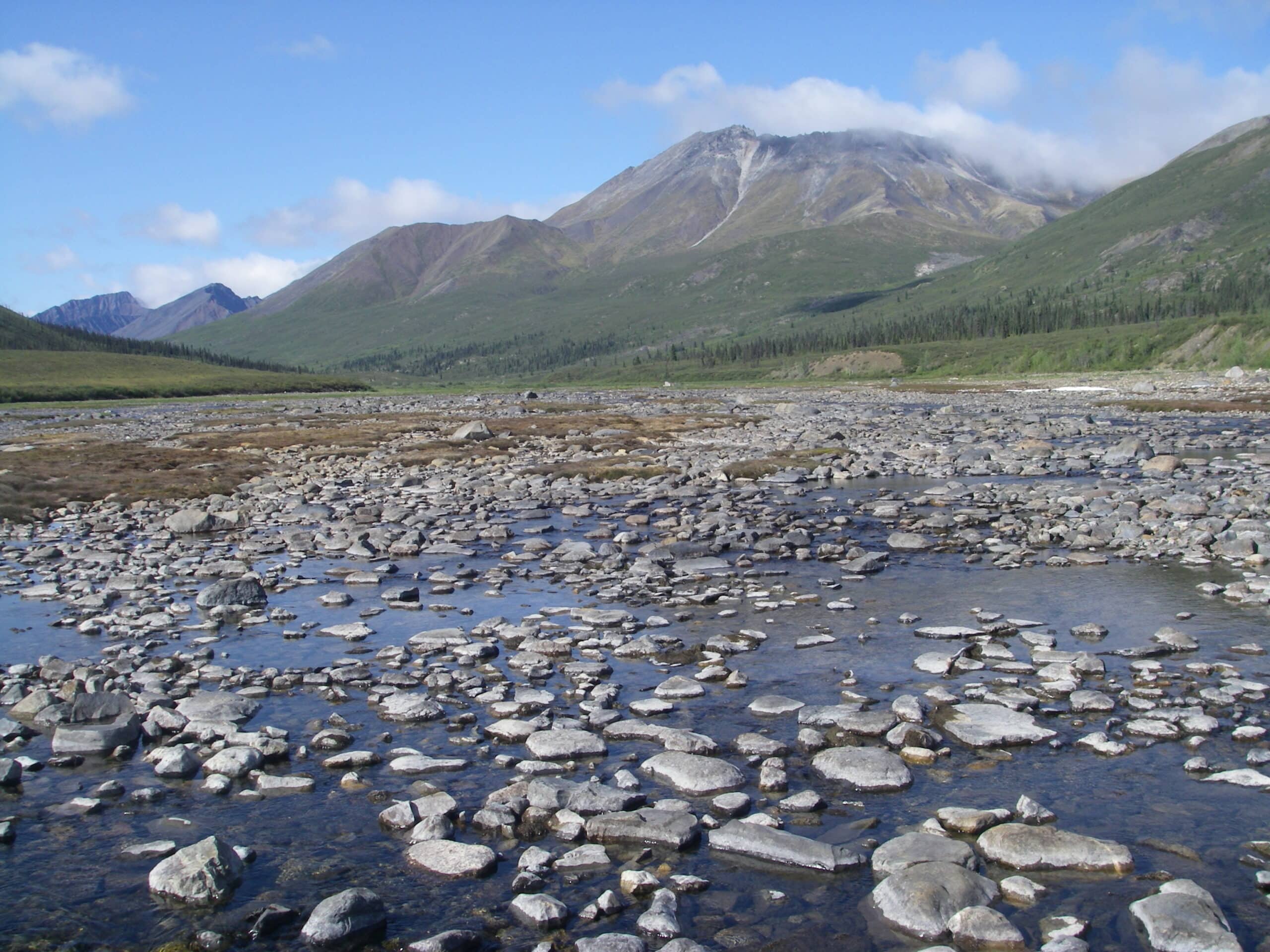
Landscape
Forty Mile lies in a broad valley at the confluence of the Yukon and Fortymile rivers. The valley is flanked by low, rounded mountains. The site is part of Beringia, a great band of land extending from Siberia to the Northwest Territories that remained unglaciated during the last major ice age between about 10 and 25,000 years ago. This area is rich in minerals which include gold, asbestos and coal deposits.
Forty Mile also lies within the Tintina Trench, an immense valley that traverses the Yukon Territory from southeast to northwest. The eight-million-year-old Trench is underlain by a huge fault along which bedrock has shifted as much as 450 km. It is an important wildlife migration route and a flyway for species such as sandhill cranes, swans and peregrine falcons.
The presence of permafrost in the ground has done much to shape and alter the landscape. When covered with insulating vegetation, this permanently frozen ground can be quite stable. Unfortunately, early builders did not understand this and cleared the ground to erect their buildings. The frozen ground, stripped of its cover, then melted and froze again causing the surface to sink and heave. The buildings sitting on this active ground also shifted and buckled, causing rapid deterioration.
Hydrology
Two major rivers affect the land under Forty Mile. The Fortymile River is one of the major tributaries of the Yukon River and is located mostly in Alaska. The silts carried down the Fortymile River created a large shallow bar at the tip of the townsite. The bar prevented large boats from docking here. The Forty Mile site was once an island but heavy silts from the Yukon River eventually filled in the channel making it part of the mainland.
To learn more, see the story here.
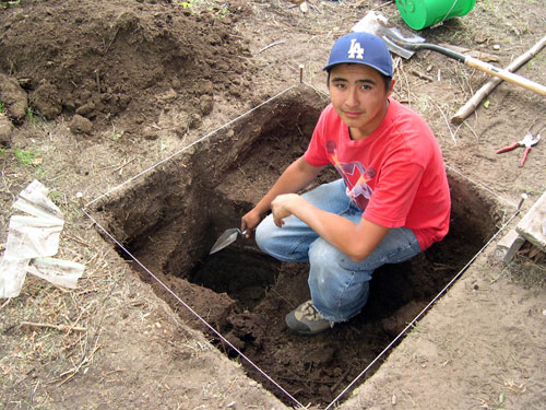
Archaeology
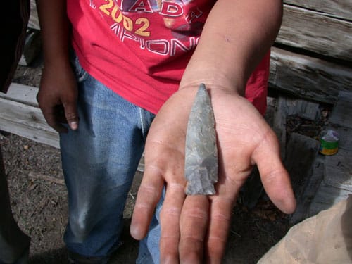
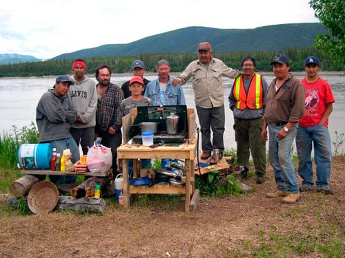
Artifacts at Forty Mile range from tiny stone chips to immense pieces of industrial machinery. Archaeological work at Forty Mile began in 1998 and continued for eight seasons. These projects were co-sponsored by the Tr’ondëk Hwëch’in and the Government of Yukon.
According to archaeologist Christian Thomas, Forty Mile “likely contains the most detailed record of human history in the central Yukon for the time period spanning the last 2500 years and maybe more.” As well as finding stone tools, archaeological crews have found bone needles, bone arrow heads, birch bark baskets and countless fragments of processed caribou bone (used to make tools
Forty Mile Timeline
Archaeological investigations show that this place was a base for First Nations people who hunted and fished in the area.
Jack McQuesten of the Alaska Commercial Company set up the first trading post in Tr’ondëk Hwëch’in traditional territory at Fort Reliance. Hän people helped build the store and hunted for the traders.
September, Harry Madison and Howard Franklin discovered coarse gold on the Fortymile River, 23 miles above its mouth.
The gold find on the Fortymile River attracted hundreds of miners. Hän people helped Jack McQuesten and Arthur Harper build an Alaska Commercial Company trading post at the confluence of the Fortymile and Yukon Rivers. Around it grew the log cabin community of Forty Mile.
Anglican missionaries, Bishop William Carpenter Bompas and his wife Charlotte, arrived at Forty Mile with to build a school and church. The First Nations camp was built around the church buildings on Mission Island. The Bompas’ took in a few children to board and their home became the Yukon’s first residential school.
American trader John J. Healy of the North American Trading and Transportation Company (NATT) built a new trading post, Fort Cudahy, across the river from Forty Mile.
16 August - George Carmack, Dawson Charlie and Skookum Jim staked the discovery claims on Rabbit (soon renamed Bonanza) Creek. Soon after the claims were registered at Forty Mile, miners begin stampeding upriver to the new diggings.
After being “almost deserted” the previous year, the population of Forty Mile was recorded as “200 white men and 80 Indians”. Mounties set up a two-man town detachment at Forty Mile. According to Inspector Scarth, most of the First Nations people living there mostly came from Alaska or “the other side of the line.”
Telegraph office opened at Forty Mile. The Dominion Telegraph Line was extended to the American border and then connected with the US Signal Corps system.
Potlatch held to celebrate Peter becoming hereditary chief of Fortymile people replacing his father David. First Nations people attended from Moosehide, Peel River, Tanana, Mackenzie River and Charley Creek areas.
The one-man RCMP detachment was closed.
Death of Bill Couture, the last resident of Forty Mile.
October, Cassiar Asbestos Corporation Limited opened an open pit asbestos mine at Clinton Creek, upriver from Forty Mile. The historic townsite became a recreational area for the miners and their families.
Tr’ondëk Hwëch’in citizens began negotiating for a land claim settlement. The Forty Mile site was identified as being significant to Hän culture and history.
Closing of asbestos mine and abandonment of company town at Clinton Creek.
Signing of the Tr’ondëk Hwëch’in final agreement at Moosehide Gathering.
T.J. Hammer began archaeological work at Forty Mile. He and Chris Thomas work with Tr’ondëk Hwëch’in students over the next eight summers to help document the prehistoric heritage of the area.
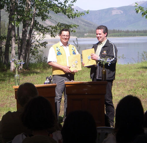
June 11 - Signing of the Forty Mile Management Plan in a ceremony at Forty Mile, hosted by Tr’ondëk Hwëch’in and Yukon Government.
Gallery